Tri-State Markers / Triple Points, State High Points, Corners & State Centers
Tristate, Tri-points or Triple points, aka trifiniums all mean the same thing. These are places where three States come together at a common point. Almost everyone is familiar with Four Comers in the southwestern U.S., where Utah, Colorado, Arizona and New Mexico meet at a spot in the Navajo Indian Reservation. However, not many people realize that there are sixty-one other spots where three States join. Of this total of sixty-two, thirty-eight either have markers or should have markers on land. The rest are in the middle of rivers, streams or lakes where no identifying marker can be placed.
This endeavor could be extended to include tri-points along the U.S.-Canadian and U.S.-Mexican borders. There are eleven locations where two U.S. States meet a Canadian province and seven more where one State hooks up with two provinces. Similarly, at three spots, two U.S. States join at a Mexican State, and at five other locations, it is two Mexicans adjoining one U.S. State. This gives a grand total of twenty-six locations of which only ten are on dry land.
An excellent guide to Tripoints, geographical Highpoints and Lowpoints can be found at the Highpointers Club website.
Four Corners Monument marks the quadripoint in the Southwestern United States where the states of Arizona, Colorado, New Mexico, and Utah meet.
Four Corners (AZ-CO-NM-UT) is really four tri-State points in one location, but is counted as the only spot in America where 4 states meet, the tri-state points are not as famous and most people are not curious enough to travel long distances out of the way for them.
36°59’56.3″N 109°02’42.8″W 36.998961, -109.045209
The area is very remote. The tiny community of Teec Nos Pos, AZ, is six miles away and it has a gas station.

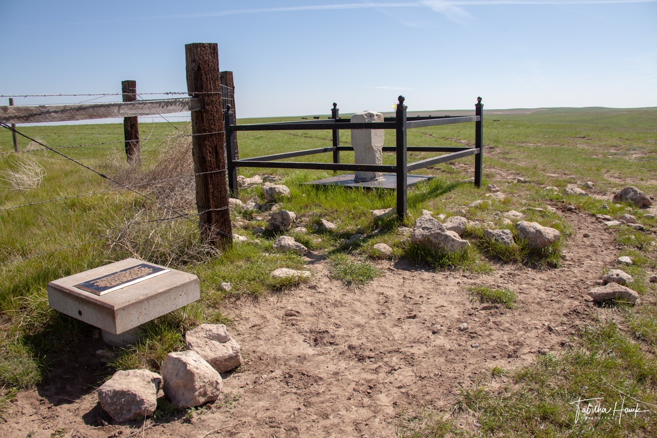
Colorado-Kansas-Nebraska Tripoint Marker
GPS – 40.003198, -102.051785
To reach Three Corners from St. Francis, first drive to Devil’s Gap by driving north of St. Francis on K-27 to Road W, approximately 13 miles north of the K-27 and US-36 Junction, then follow the hand made signs. From Devils Gap, continue north on County Road 3, turning west into private land at the red marker. Continue on the private road for 2 3/4 miles in a northwest direction following the signs. This will actually take you into Colorado for the last part of the route.
THE CORNER COMMON TO NEBRASKA AND KANSAS ON THE COLORADO LINE
The survey of the base line of the 6th principal meridian, which also marks the boundary between Nebraska and Kansas, was extended from the Alma, Nebraska area to the summit of the Rocky Mountains by Jarret Todd and James Withrow in 1859.
In 1869 Oliver N. Caffee [sic] surveyed the western boundary of Nebraska, and failing to locate the baseline, set the limestone monument 621.7 feet South of this position.
In 1872 John J. Majors surveyed the boundary between Kansas and Colorado, commencing at Chaffee’s monument.
On June 15, 1873 Edwin Burwell intersected the baseline with Chaffee’s state line and established the corner of Nebraska and Kansas on the Colorado line.
On October 17, 1990 the Bureau of Land Management re-monumented this tri-state corner.
In recognition of those early Surveyors, the skills they demonstrated and the hardships they endured, we dedicate this Plaque on June 1, 1991.
According to the Congressional definition of the boundary of Colorado, this point is theoretically where the 40th parallel north latitude intersects 25 degrees west longitude as measured from the Washington Meridian*. However, this monument was first set by Oliver Chaffee during his 1869 survey — and due to the technological limitations of his day, it is not exactly right (although his survey does define the official boundary, regardless of its accuracy).
* Many American surveys between 1850-1884 were based on the Washington Meridian, which was officially abolished by Congress in favor of the Greenwich Prime Meridian in 1912. “25 degrees west of Washington” is a few miles away from the 102nd degree of longitude west of Greenwich.


Colorado – Nebraska – Wyoming Tristate Marker
GPS: 41.001651, -104.053169
Directions
Leave Interstate 80 at exit #401 at Pine Bluffs, WY. Go N to 8th Street, then E on 8th Street for 0.6 mile to Beech Street. Go S on Beech 12 miles to the CO line. Turn E through a gate and drive 3/4 mile on a pasture road along the WY – CO border past a wind mill to the tri-State marker. In wet weather you may want to park prior to the windmill and walk the remaining 1/4 mile.
The Nebraska high point, Panorama Point, at elevation 5424 feet, is 1.3 miles ENE of the tri-point. Do not hike between the tri-point and the high point, as it is open bison range. Drive around (from the tri-point W, S, E. N, and finally W again) on farm roads.


Kansas, Colorado and Oklahoma Tristate Point
Also known as Eight Mile Corner Tristate point
GPS: 36.993231, -102.042043
Directions: To reach Eight Mile Corner: from the edge of Elkhart where Oklahoma Highway 95, Kansas Highway 56 and Baca Avenue intersect, turn north onto Baca, cross the railroad tracts and then turn west on County Road A (better known as State Line Road) and drive eight miles. State Line Road is unpaved, but kept in pretty good condition. A short stretch at the Tristate Point is paved.


Arkansas – Missouri – Oklahoma Tristate Point Marker
GPS: 36.499505, -94.617808
ACCESS ROUTE: From South West City, MO, go S about 1 mile on Route 43 which becomes OK Route 20. The monument is on the W side of the highway just off the shoulder. Across the road from a gas station which is at 1000 S Main St, Southwest City, MO 64863


Kansas, Oklahoma and Missouri Tri-State Marker
GPS: 36.998597, -94.617937
Directions: 1183 SE 118th St, Joplin, MO 64804
The tri-point of Missouri, Oklahoma, and Kansas is just off of Interstate 44 at exit 1 near Joplin, Missouri. A short side road goes directly to the point from a road to an Oklahoma casino (although the road starts in Missouri and is mostly in Kansas).
A stone monument marks the location of what was formerly thought to be the tri-point, but the area was resurveyed an a new marker (photo below) was placed about 50 feet from the original one in 2004.


Indiana, Ohio and Michigan Tristate Marker
GPS: 41.696123, -84.805956
Michigan – Indiana – Ohio State Lines
3285-4549 N 1000 E, Fremont, IN 46737
Directions: Finding the Tri-State bench marker is easy. About seven miles east of Fremont on Rd. #120 you meet the Michigan line. A little road (Cope) leads south. Proceed 0.7 miles. Long Lake is in both Indiana and Michigan. The west end of the lake is in Clear Lake Twp. (Indiana’s most northeastern township) in Steuben County. The east end of the lake is in Hillsdale County, Michigan. Five miles south of Long Lake you can see an important bench mark where the three states (Indiana, Michigan and Ohio) join.

Colorado, New Mexico and Oklahoma Tristate Marker
AKA Preston Monument
GPS: 37.000105, -103.002200
Directions: From Kenton, Oklahoma, follow signs to the Black Mesa Nature Preserve. You’ll pass the trailhead for Black Mesa (the Oklahoma High Point) and continue on dirt roads to the monument.


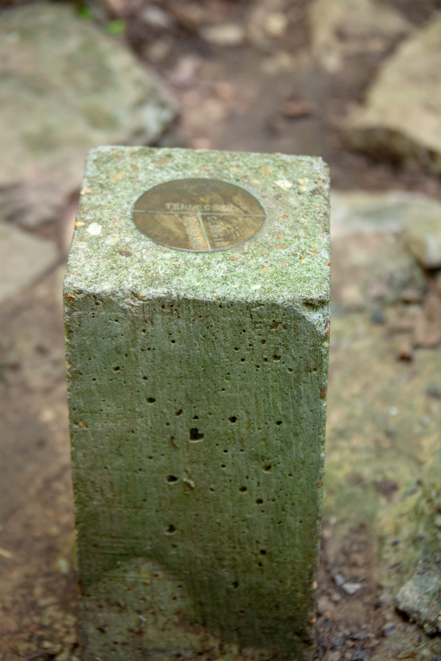
Tennessee, Georgia and Alabama Tristate Marker
GPS: 34.984681, -85.605164
Directions: Nickajack reservoir, and followed Macedonia Road and Coal City Hollow Road to the State Line Cemetery, where we pulled to the west end of the cemetery and parked out car.
From the parking area at the corner of the State Line Cemetery, go west through a hole in the brush for the trail. Do not bear right at the top of the grade but go straight onto the vague trail. At this time, there was a blow down with pink tape which some thoughtful person put there. Step over this tree and you’ll spot the Maypole at 10 o’clock.

Georgia, North Carolina and Tennessee Tristate Marker
GPS: 34.988400, -84.321867
Directions: I parked at Jade Lane nearby a fence and walked along the fence and down a hill then crossed a small creek that I jumped over then walked up towards the triple point.
From Copperhill, TN I headed east on TN-68 S/Toccoa Ave, Turn left onto Harris Rd, Turn right onto Jasper Rd, Turn left onto Jade Ln
Destination will be on the right

Connecticut – Massachusetts – Rhode Island Tri-state marker
GPS: 42.008060, -71.799245
At a point where the three southern New England states, Connecticut, Massachusetts, and Rhode Island, meet, is a four-sided monument with the states engraved on the sides.
The marker is located off a rail trail that runs through both Connecticut and Massachusetts. In Connecticut, it is known as the Airline State Park Trail. In Massachusetts, it is known as the Southern New England Trunkline Trail. The best way to get there is to drive on Southwest Main Street (Douglas), through the state boundary line into Connecticut, then drive roughly a mile to the village of East Thompson where there is a dirt parking area by where the Airline Trail crosses the road. From there, walk east along the trail until you see a trail junction where there is another state boundary marker, between Connecticut and Massachusetts. Walk along this trail south to the marker. The one-way distance is about a mile. There are other trails that meet at this marker. A link to a map is included – my suggestion is to print it out before you go – I saw no printed map showing this trail in the area.
The marker is a typical stone monument, standing about four feet tall and about 14 inches on a side. There is a pyramid on top. On the sides are as follows: North: “MASS 1883”, South: “RI 1883” and West, “Conn” (the east side is also in Massachusetts).
According to one source, a commission between Massachusetts and Rhode Island set this marker. Since then, in 1940, the marker was confirmed to be accurately marking the boundary.


Iowa, Minnesota and South Dakota Tristate Marker
GPS: 43.5005402,-96.4540389
26799 488th Ave, Valley Springs, SD 57068
Directions: : From Interstate 29 in SD, take US 18 East about 20 miles to Inwood, lA. Then go N out of Inwood to Larchwood on route 182, which joins route 9 before reaching Larchwood. Coming into Larchwood, leave route 9 and continue straight N about 3 miles on Rt. K 16 to the MN line. Turn left (W) on a boundary line road and proceed about mile to the tri-point in the middle of the road at a tee intersection. There is a brass pin in the middle of the road, and a plaque on a monument in SD beside the road.


Minnesota – North Dakota -South Dakota Tristate Marker
GPS: 45.935251, -96.563704
Directions: : From Interstate 29 in SD, use exit 246 and go E and then N on route 127 to White Rock Road, which is 1 mile S of the ND – SD line. Lakeview Cemetery is at the NE corner of this intersection. Go E for 2 miles on the White Rock Road, then 1 mile N to the ND state line. Turn E and go a little over 1/2 mile on a farm lane to the ND – SD stone marker #1. There is a drainage ditch along the right (S) side of this road. The tri-point should be between the ND – SD marker and the river but no monument or marker could be found in that area. The Boise de Sioux River is a little over 0.1 mile E of the ND – SD marker.


Texas – Oklahoma – New Mexico Tristate Marker
GPS: 36.500546, -103.002458
Directions: Between Clayton, New Mexico and Boise City, Oklahoma, turn off Highway 412 on either dirt road. Follow it to the end and walk over a cattle guard. After you visit this marker, be sure to visit the Northwest Texas Corner Marker which is two miles to the west.


Texas – Louisiana – Arkansas Tristate Marker
GPS: 33.019221, -94.042969
Directions: 78230 TX-77, Atlanta, TX 75551 The Tri-Point is along LA Hwy 1 / Tx Hwy 77. There is parking nearby at a local pub.


Tennessee – Virginia – Kentucky Tristate Marker
GPS: 36.600815, -83.675418 for spot, 36.600955, -83.669427 for parking lot for the trail.
Tri-State Peak Trail is a 2.2 mile out and back trail located near Cumberland Gap, Tennessee, it is a decent grade and wore me out, though someone in better shape might find it easier. It is a pretty view when you reach the top and has a nice area of signs.


High Points of States
Highly doubtful I’ll get to the high points of every state but here are some that I’ve visited since 2015.
North Carolina High Point
Mount Mitchell is the highest peak at 6,684 feet, east of the Mississippi River, and east of the Appalachian Mountains and the highest peak in mainland eastern North America. This is the 16th highest point for the states.


New Hampshire High Point
Mount Washington, is the highest peak in the Northeastern United States at 6,288.2 ft and the most topographically prominent mountain east of the Mississippi River. The mountain is notorious for its erratic weather. On the afternoon of April 12, 1934, the Mount Washington Observatory recorded a windspeed of 231 miles per hour (372 km/h) at the summit, the world record for most of the 20th century. This is the 18th highest state high point.


Maine High Point
Mount Katahdin is the highest mountain in Maine, the highest point in Baxter State Park, and the northern terminus of the Appalachian Trail. Katahdin is the 22nd highest state high point.


Tennessee High Point
Clingmans Dome is a mountain in the Great Smoky Mountains of Tennessee and North Carolina, in the southeastern United States. At an elevation of 6,643 feet, it is the highest mountain in the Smokies, the highest point in the state of Tennessee, and the highest point along the 2,174-mile Appalachian Trail.


Ohio High Point
Campbell Hill is, at 1,550 feet (470 m), the highest point in elevation in Ohio. Campbell Hill is located within the city of Bellefontaine, 2 miles (3.2 km) northeast of downtown. The peak is the former home of the Bellefontaine Air Force Station, where the 664th Aircraft Control and Warning Squadron maintained a Cold War early warning radar. Campbell Hill ranks 43rd in height on the list of highest natural points in each U.S. state.


Nebraska High Point
Panorama Point is the highest natural point in Nebraska, at an elevation of 5,429 feet (1,655 m) above sea level. It is located in southwestern Kimball County, near the point where Nebraska and Wyoming meet on Colorado’s northern boundary. Despite its name and elevation, Panorama Point is not a mountain or a hill; it is merely a low rise on the High Plains. A stone marker, giving the elevation at 5,424 feet (1,653 m),[3] and a guest register are located at the summit of the drive.


Oklahoma High Point
Black Mesa reaches 4,973 feet (1,516 m), the highest point in the state of Oklahoma. Black Mesa is a mesa in the U.S. states of Colorado, New Mexico, and Oklahoma.

Florida High Point
Britton Hill is the highest natural point in the state of Florida, United States, with a summit elevation of 345 feet (105 m) above mean sea level. Britton Hill is the lowest state highpoint in the United States, 103 feet (31 m) lower than the next lowest highpoint, Ebright Azimuth in Delaware

Alabama High Point
Cheaha Mountain is the highest natural point in the U.S. state of Alabama at 2,407 feet. It is located a few miles northwest of the town of Delta in Cheaha State Park. Cheaha Mountain is part of the Talladega Mountains, a final southern segment of the Blue Ridge Mountains, unlike other elevations of the Appalachians in north Alabama, which are part of the Cumberland Plateau. The mountain is the highest point in the eastern portion of the Sun Belt (east of the Mississippi River, south of Interstate 20, and north of the Gulf of Mexico).


Iowa High Point
Hawkeye Point is the highest natural point in Iowa at 1,670 feet (510 m). It is approximately 4.5 miles (7.2 km) north of Sibley on the eastern side of SR 60 and approximately 3.5 miles (5.6 km) south of the Iowa-Minnesota state border.


Geographical Center of States
Unlikely I will get many of these but since I grew up in Ohio and live in Tennessee I figured at least start there.
Geographical Center of Tennessee
307 Old Lascassas Rd, Murfreesboro, TN 37130 | 35.859764, -86.361951


Geographical Center of Ohio
Memorial Park US-36 & OH-314, Centerburg, OH 43011 | 40.309317, -82.692250
Another Marker nearby at 57-61 Cleveland Ave Centerburg, OH 43011 | 40.308615, -82.697859


Corners of States
They are not as glorious as tristate points but corners are often close to Tristate Points so why not include them as well.
Northwestern Corner of Texas
GPS: 36.500348, -103.041928
Helpful directions can be found here.
Very nearby is the tripoint marker for Texas, New Mexico and Oklahoma


The Northeast Colorado Corner Monument
GPS: 41.002355, -102.051613
Directions: From Julesburg, travel east on Interstate 76. Cross the Nebraska state line and turn south at exit 107 in Big Springs, Nebraska. Take that road about two miles south until it makes a hard left. At that point, you’ll be driving along the Colorado / Nebraska border. Take it about 0.5 miles east and at the “T” intersection, the marker sits.
Colorado – Nebraska Corner Border Marker


Delaware Arc Monument
This marks the meeting point of the12 mile circle aka Delaware Arc and the PA Mason Dixon Line. This marks the DE-PA state boundary line at the intersection of the east-west southern boundary of Pennsylvania what was known as the Wedge to the west of this spot with the 12-mile Circle boundary line centered on Newcastle, DE.
To the west of this point is a small area known as The Wedge. The Delaware Wedge is a 1.068 square-mile, roughly triangular chunk of land that sits at the point where Pennsylvania, Delaware and Maryland all bump up against each other. Born of the shortcomings of a survey to settle another border dispute, the Wedge was disputed territory almost as soon as the colonies were established, and Delaware and Pennsylvania’s battle over the land wasn’t completely resolved until 1921 when Delaware got it.


Northwest Corner of Kansas
40.001536, -102.051821
Not a tripoint but this is a short walk or drive from the Colorado-Kansas-Nebraska Tripoint Marker


